Adventure #14
SCALE HELL’N MORIAH & THE MAJESTIC NOTCH PEAK SUMMIT

Ready for fun scrambles, challenging hikes, and breathtaking views from North America’s second-tallest sheer cliff face? Notch Peak is a towering desert limestone monolith offering an exhilarating all-day experience you won’t forget. Whether you choose to admire it from below or conquer the peak and take in the view from above, this destination will not disappoint.
So grab your water, lace up your hiking boots, and prepare for a thrill!
A Little About Notch Peak
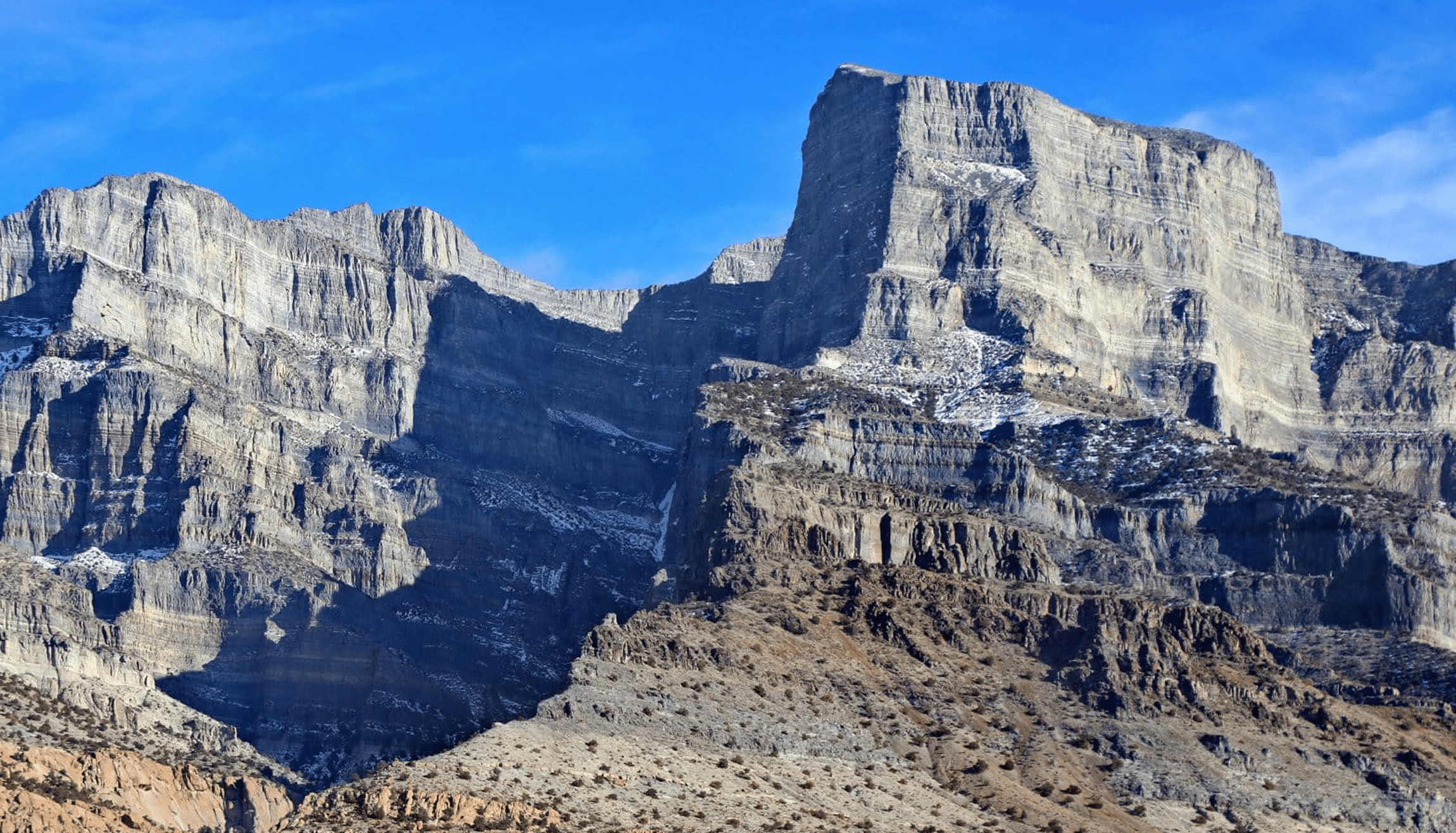
Notch Peak is a distinctive summit nearly 3,000 feet tall, located on Sawtooth Mountain in the House Range west of Delta, Utah — part of the Notch Peak Wilderness Study Area. This awe-inspiring cliff towers approximately 9,725 feet above sea level, surrounded by 3,000-year-old bristlecone pines on its ridges. These gnarly trees twist out of the rock toward the sun, spreading across the slope, and are thought to be some of the oldest living things on Earth!
Due to its proud grandeur and impressive height, visitors affectionately refer to Notch Peak as the desert equivalent of Yosemite’s El Capitan. It offers solitude and some of the most spectacular views of Utah’s Great Basin and parts of Nevada. Even if you’re not ready to hike to the top, there’s still a lot to love from the trail below, ensuring everyone can enjoy the experience.
How to Get There
GPS COORDINATES:
Notch Peak is located approximately 44 miles southwest of Delta. To get there from Delta:
 |
Head west on Delta Main Street/US-50/6. Proceed for approximately 36 miles. |
 |
Turn right and follow the gravel road for ~4.5 miles until you reach a four-way intersection. |
 |
Turn left and drive for 1.26 miles and turn right. |
 |
Continue for around 5.13 miles until you reach the OHV trailhead with a restroom and pavilion. |
 |
Turn left and continue on for 3.2 miles to the Hell’n Moriah trailhead or another 0.3 miles to the Notch Peak trailhead. |
If you simply want to drive around Notch Peak:
 |
Take the loop of maintained gravel road 52 miles west of Delta by turning right off of US Highway 6 & 50. The 50-mile loop circles around peaks in the rugged House Range to Painter Springs and offers the most amazing view of Notch Peak from the valley, allowing you to see the true majesty of this magnificent peak. |
 |
Follow Tule Valley road northward to Dome Canyon Pass, also known as Death Canyon. Go through the pass. |
 |
Head south around the eastern side of the range and back to the Highway. |
The loop will take at least 2 hours of traveling, plus any time you want to spend sightseeing.

What to expect & how to prepare
Notch Peak is about a 7-mile round trip from the trailhead off of Sawtooth Canyon. The hike is moderately challenging overall, but the final quarter mile to the top is relatively steep and difficult. Plan on an all-day hike.
| What to bring: Bring sunscreen, snacks, and plenty of water, as there are no water sources along the trail. Some hikers say sections of the trail are often overgrown and require long pants as well as sturdy hiking shoes due to gravel and loose rocks. When visiting Hell’n Moriah, you’ll also need an extra spare tire or a tire repair kit, as the roads can be rocky. We recommend taking a high-clearance or 4WD vehicle. |
| What to do: If hiking isn’t your thing, there’s still plenty to do. With a pair of binoculars and a camping chair, you can enjoy a day of bird-watching along the trail. Some people also enjoy the easy scrambles along the path or will bring gear for rock climbing. There’s even a slot canyon trail on the south side of the road before you reach the Notch Peak trailhead. Hell’n Moriah is a two-mile hike into the slot canyon and is best for experienced climbers with good shoes, gloves, and rope. |
| Dog-friendly: Dogs are welcome. There are some areas where they may even be permitted off-leash. |


Best Time to Visit
Notch Peak and Hell’n Moriah are best hiked in March through October, mainly in the spring and fall when temperatures are moderate and foot traffic is lighter. Hiking Notch Peak in the heat of summer brings greater risk, so proceed with caution and prepare well.
Additional Adventure: Hell’n Moriah
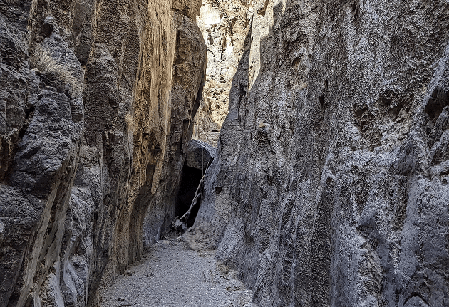
Hell’n Moriah is an overlooked gem with fewer visitors than the Notch Peak trail. Located on the south side of Notch Peak in the House Range, the Hell’n Moriah slot canyon route has dramatic high-walled limestone narrows and unique scenery that rewards all willing to venture into its depths. Hikers have described its narrows as the most beautiful in Utah’s West Desert, with sheer, vertically fluted walls riddled with pockets and fossils.
Hell’n Moriah is named on USGS topographic maps, but the hiking route is unofficial as there’s no developed or maintained trail. Instead, hikers follow an old, closed two-track road and the natural canyon wash to explore the narrows.
How to Get There
GPS COORDINATES:
Hell’n Moriah Canyon is accessible via the Notch Peak/Sawtooth Canyon road. From Delta:
 |
Head ~40 miles west on US 6 & 50 to just past milepost 48. |
 |
Turn north onto the signed gravel road toward Miller Canyon. |
 |
Follow this dirt road into the House Range, staying on the main track at key junctions (e.g., turn left at 4.3 miles into Miller Canyon and left again at ~9.5 miles near a BLM picnic area). |
 |
After about 12.8 miles, the road ends at a parking area used as the trailhead for Hell’n Moriah Canyon. |
 |
The Hell’n Moriah route starts on the south side of the road, just before the Notch Peak trailhead, following an old two-track that enters the mouth of the canyon. |

What to expect & how to prepare
Be prepared for a two-mile hike into the slot canyon. The full experience is best for experienced climbers with good shoes, gloves, and rope.
 |
Time & distance to hike: Most visitors hike Hell’n Moriah out-and-back into the canyon’s narrows. The hike is about 4 to 5 miles round-trip (approximately 2 miles each way) and typically takes 2 to 5 hours. |
 |
Difficulty: The canyon is rated as moderately difficult, and route-finding is straightforward, with no navigation challenge in the narrows. However, the scrambling and remote location are best suited for experienced hikers. |
 |
Precautions: The last few miles approaching Hell’n Moriah are rough. High clearance and 4WD are recommended. Travelers should also carry a spare tire or tire repair kit, as the sharp rocks have been known to cause flats. |
 |
Amenities: The area is extremely remote and has no services, so come prepared with ample fuel, water, food, and emergency supplies. |
 |
Option for a full technical descent: The full technical descent should only be attempted by highly qualified climbers who know the area. This option requires two vehicles and expert gear/skills but offers a complete tour of the canyon. Only experienced technical canyoneers should attempt the full traverse. |
Best Times to Visit
The canyon is best explored in spring and fall. Summer days can be extremely hot in this desert region, and the slot offers little escape from heat. Winter is generally off-season unless the ground is mostly free of snow and ice.
Always check weather forecasts; while Hell’n Moriah has a relatively low to moderate flash-flood risk, any slot canyon can be dangerous in heavy rain.
